

The Framework for Ecosystem Restoration Monitoring (FERM) builds on, and complements, existing international, regional and national reporting processes, their goals, targets, criteria and indicators by providing to people, communities and countries, under one common umbrella, providing access to data, methodological guidance and tools to monitor ecosystem restoration.
The guiding document: Delivering restoration outcomes for biodiversity and human well-being
FERM supports the reporting of areas under restoration in support of the UN Decade on Ecosystem Restoration and towards the Kunming-Montreal Global Biodiversity Framework (GBF). The FERM is aligned with the methodology for monitoring and reporting the headline indicator of the restoration target of the GBF, Target 2, to restore at least 30 per cent of areas of degraded ecosystems by 2030.
Sharing knowledge and information is a key element of the Ecosystem Restoration community. The platform improves knowledge sharing, provides access to data and information and links partners to enhance collaborative actions. The FERM highlights successful restoration projects and programs for joint learning of all actors at national and subnational levels.
FERM adheres to principles of open data and open-source technical solutions to ensure transparency in the Monitoring Framework, and improved access to data and information between stakeholders. FERM supports all restoration stakeholders to track and monitor contributions to the UN Decade and with the idea of building a global movement and creating inertia towards restoring degraded landscapes.
Data collectors can continue their work uninterrupted regardless of internet availability, a frequent challenge in forests, rural communities, or protected areas. The app supports capture of diverse data types, including numeric measurements, GPS locations, images, audio, video, and textual notes, enabling comprehensive data collection tailored to a wide variety of survey needs.
Designed For
FERM is for anyone involved in implementing and monitoring restoration activities. Restoration actions are carried out by different stakeholders across society, including national government, local government, NGOs, local communities, researchers, Indigenous Peoples, the private sector, multi-national efforts, and more. These stakeholders can share their restoration data to contribute towards the global restoration Target 2, which focuses on monitoring areas under restoration and sharing of their best practices.
Workflow
FERM operates through a streamlined process that enables users to register and monitor, visualize, and explore restoration data from all ecosystems through its functionality.
The FERM Registry is designed to document data from all ecosystem types (terrestrial, aquatic and transitional), providing a comprehensive data entry format for restoration initiatives and good practices. It provides a harmonized approach to data collection on restoration areas, aligned with the GBF Target 2 indicator methodology.
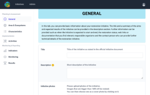
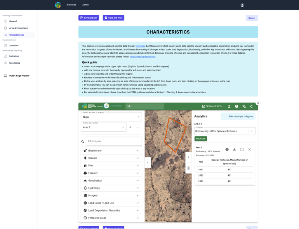
Planning and Assessment: The General tab includes essential project details, including the title, description, restoration type, status, tenure, start year, and SDG contributions. The Area and Ecosystems tab includes restoration commitments and areas under restoration disaggregated by ecosystem, allowing users to upload GIS files, draw polygons, and identify ecosystems in the process of restoration. The Characteristics tab integrates geospatial information relevant to restoration, enabling users to analyze and understand the ecosystems under restoration.
Implementation: the Activities tab documents enabling and biophysical activities carried out on the ground.
Monitoring and Reporting: Allows users to select or input restoration indicators (Indicators tab), track progress over time (Monitoring tab), and preview initiative data before publication (Preview tab).
The FERM is built on FAO’s corporate Hand-In-Hand geospatial architecture and provides accessible and transparent information for restoration practitioners. In addition, restoration data is integrated into a customized version of Earth Map for FERM. The geolocation of restoration projects are visualized on interactive maps that enable monitoring of areas under restoration.
Earth Map is a web-based application constituted by a map where geospatial layers can be easily displayed and statistics generated on the fly thanks to its graphical user interface. Earth Map delivers high-quality, up-to-date satellite imagery and geographic information, enabling users to monitor the restoration progress of initiatives. It facilitates the tracking of changes in land cover, land degradation, biodiversity, and other key restoration indicators. By integrating this data, the tool enhances the user’s ability to assess progress and make informed decisions, ensuring effective and transparent ecosystem restoration efforts.
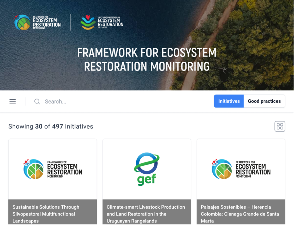
The FERM Search Engine is co-developed by both the UN Decade Monitoring Task Force and the UN Decade Best Practices Task Force. It facilitates knowledge-sharing and enhances transparency of restoration initiative data and good practices, which have been reviewed and published for public access.
The initiatives search engine consolidates ecosystem restoration initiatives from multiple platforms, allowing users to efficiently search, filter, and access detailed information in one place. For published FERM initiatives, users can view key documentation aspects and indicators, providing a comprehensive overview of restoration efforts.
Good Practices: To support learning and knowledge-sharing, good practices (GP) from restoration initiatives must be documented and shared to avoid mistakes and scale effective efforts. The FAO-led Task Force on Best Practices collaborates with the Monitoring Task Force to integrate GPs from various platforms into a common search engine. https://ferm.fao.org/search/good-practices
Resources
Materials & Resources
- FAO eLearning Academy Course: Delivering Restoration Outcomes for Biodiversity and Human Well-being
- Delivering Restoration Outcomes for Biodiversity and Human Well-being – Resource Guide to Target 2 of the Kunming-Montreal Global Biodiversity Framework
- UN Decade on Ecosystem Restoration
- Ecosystem Restoration Monitoring
Donors & Collaborators

UK Government

AIM4Forests
The federal Government
of Germany