
Operationalizing and institutionalizing innovative technologies for using geospatial data is key to producing accurate, transparent information critical for reversing climate change, reducing deforestation and degradation, and catalysing restoration and conservation. The first phase of SEPAL was successfully carried out from 2016 to 2021, implemented by the Forestry Division of the Food and Agriculture Organization of the United Nations (FAO) and financed by an initial contribution from Norway’s International Climate and Forest Initiative (NICFI). The second phase – Forest and Land Monitoring for Climate Action – is a four-year project that aims to improve climate change mitigation plans and create better informed land-use policies.
It is connected to modern geospatial data infrastructures, such as Google Earth Engine (GEE), further driving the generation of high-integrity forest and land-use data that enable countries to attract public and private carbon finance for forest-related climate action. SEPAL caters to specific monitoring and reporting needs through dedicated modules, such as SE.PLAN for spatially explicit forest restoration planning, SEPAFE to receive and validate fire alerts, and BFAST-GPU for running dense, large-area, time-series analyses.
SEPAL’s goals are to support countries in their efforts to halt tropical deforestation and degradation, and to enhance reforestation and restoration by:
- providing a free, easily accessible, powerful platform for efficient geospatial data access and customized processing;
- enhancing global capacity to operationally apply high-resolution satellite images to critical forest and land monitoring issues; and
- building country capacity in high-resolution satellite imagery applications for critical forest and land monitoring issues in response to domestic policy needs.
The project will directly benefit countries through different capacity-building modalities toward autonomous use of the data for key forest and land monitoring needs. In addition, some countries will receive targeted support and commitment, leading to the institutionalization of data use at the national level, thus strengthening institutional arrangements and linkages to policy formulation, implementation and evaluation through capacity development at the national level
Key Features

Inclusive for All Users: SEPAL is accessible to non-experts while providing advanced tools for super users, supporting the full spectrum of geospatial analysis.
Extensive Data Access: Provides access to vast archives of satellite imagery (Landsat, Sentinel-2, etc.).
Integrated Geospatial Tools: Combines various open-source geospatial libraries and tools (e.g., GDAL, ORFEO Toolbox, SNAP Toolkit) within a unified environment.
Multiple Scripting Environments: Supports geoprocessing via Jupyter Notebooks, JavaScript, Python, and R.
User-Friendly Interface: Offers both code-based and graphical user interface (GUI) options for various workflows (e.g., mosaic generation, image classification, change detection).
Capacity Building: Designed to support technical capacity development in land monitoring and remote sensing.
Collaboration: Facilitates collaborative work and sharing of scripts and results.
Designed For
SEPAL is designed for teams and organisations that need fast, reproducible, cloud-based processing of large amounts of satellite and geospatial data — especially where local computing resources or high-bandwidth connections are limited.
National Forest and Land Monitoring Agencies
Government institutions can generate, manage, and analyze satellite-based information for forest and land monitoring, supporting assessments of deforestation, degradation, and restoration, and ensuring transparent national reporting.
Climate Change Mitigation Teams
National climate units and environmental ministries produce consistent, verifiable data for climate change reporting and compliance with international frameworks such as REDD+ and the Paris Agreement.
GIS and Remote Sensing Specialists
Cloud-based geospatial tools and scripting environments allow analysts to perform land cover classification, change detection, and area estimation efficiently and at scale.
Research and Academic Institutions
Universities and research centers leverage cloud computing to conduct large-scale environmental studies and develop innovative methodologies for land use and forest monitoring.
Environmental NGOs and Conservation Practitioners
Organizations involved in conservation, restoration, and sustainable land management benefit from easy access to satellite data and processing tools for ecosystem and biodiversity monitoring.
Agricultural and Land Use Planners
Planners and land management authorities use advanced geospatial analytics to map agricultural areas, assess land use dynamics, and promote sustainable agriculture.
Workflow & Architecture

Workflow
-
In SEPAL, all processing is organized into recipes — lightweight, modular descriptions of how data should be processed. A recipe doesn’t store processed data itself; instead, it defines what to do and how to do it. When you open a recipe, SEPAL runs the computation on the fly, using the power of Google Earth Engine behind the scenes.
Recipes follow the Unix philosophy: each one performs a single, well-defined task — and does it well. You might create a recipe to build an optical mosaic, classify land cover, calculate an index, or detect change over time. By combining and chaining recipes together, you can design flexible and powerful workflows tailored to your analysis needs.
Recipes are modular, transparent, and reproducible. Each one can be inspected, modified, and reused across projects, ensuring that your analytical steps remain clear and consistent. This approach allows users to build complex processing pipelines from simple, reliable components — promoting both efficiency and scientific rigour.
-
While recipes provide the modular building blocks for data processing and analysis, applications offer ready-to-use solutions for specific objectives. Each application is designed around a particular workflow or analytical need — from forest restoration planning and deforestation alert validation to national reporting on environmental indicators.
Applications combine data access, processing logic, and visualization in a single, user-friendly interface. They enable users to carry out complex analyses without the need for custom scripting or manual setup, supporting decision-making and operational monitoring in diverse contexts.
Whether evaluating restoration potential, analyzing forest change, or producing reports for international indicators, applications help transform data into actionable insights quickly and reliably.
-
SEPAL provides users with access to dedicated server instances — isolated environments where you can work freely without competing for resources. Each instance is your own workspace: no interference from other users, no shared bottlenecks, and full control over your computational environment.
Instances come in different sizes to suit your needs — from small machines for light analysis to powerful configurations with GPUs, up to 128 CPUs, and terabytes of RAM for demanding processing or AI workloads.
Each instance includes a rich suite of pre-installed tools such as GDAL, Orfeo Toolbox, and a wide range of R and Python packages for geospatial analysis, machine learning, and data visualization. You can access your instance through a web terminal, SSH, or run development environments like RStudio and JupyterLab directly in your browser.
Certain SEPAL applications that require dedicated computational power can also be executed on these instances, ensuring smooth performance and full control over your processing.
Technology Stack
- Web Interface: Primarily developed using JavaScript. The interactive dashboard elements often utilize ipyvuetify (a Python wrapper for the Vue.js-based Vuetify component framework), for a modern, component-based UI.
- Interactive Environments: Jupyter Notebooks (for Python development) and RStudio Server (for R development) provide the integrated coding environments, accessed through the web browser.
- Core Logic: The main SEPAL backend (openforis/sepal repository) is largely built with JavaScript (likely Node.js) and extensively uses Python for scripting and integrating with geospatial libraries and services.
- Cloud Infrastructure: Hosted by FAO, it leverages various cloud-based services. Given the Google Earth Engine integration, Google Cloud Platform (GCP) services are heavily implied for underlying infrastructure, storage, and possibly serverless functions.
- Containerization: Container technologies (e.g., Docker) to manage and deploy the various processing tools and environments consistently and efficiently.
- Data Storage: Cloud-based storage solutions for vast satellite imagery archives (accessed via GEE or directly) and user-specific data/scripts.
- Google Earth Engine (GEE): The core engine for global-scale geospatial computation.
- Python Libraries: A vast array of Python libraries for geospatial data processing and scientific computing, including GDAL, Rasterio, Fiona, numpy, scipy, scikit-learn, earthengine-api, xarray, and more.
- R Libraries: Numerous R packages for statistical analysis and geospatial tasks within RStudio Server.
- Specialized Geospatial Tools: Integration of command-line tools like GDAL, ORFEO Toolbox (OTB), and SNAP Toolkit (for SAR data processing).
- Shiny: Used for developing interactive web applications (R Shiny apps) within SEPAL, often for specific analysis workflows or dashboards.
- Containerization: Container technologies (e.g., Docker) to manage and deploy the various processing tools and environments consistently and efficiently.
- Data Storage: Cloud-based storage solutions for vast satellite imagery archives (accessed via GEE or directly) and user-specific data/scripts.
- Google Earth Engine Access: Users can connect their Google accounts to access Earth Engine's multi-petabyte satellite imagery catalog and global-scale analysis capabilities without coding.
- Real-time Collaboration: The system uses WebSocket communication for real-time updates on file and asset changes, enabling collaborative workflows .
- Multi-language Support: The interface supports 9 languages including English, French, Spanish, Chinese, Russian, Arabic, Swedish, Portuguese, and Italian .
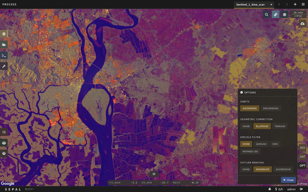
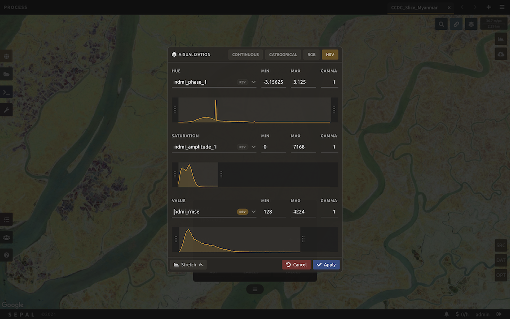
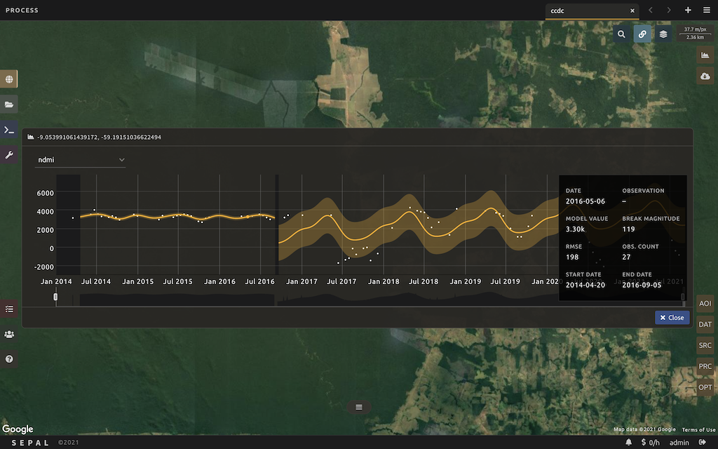
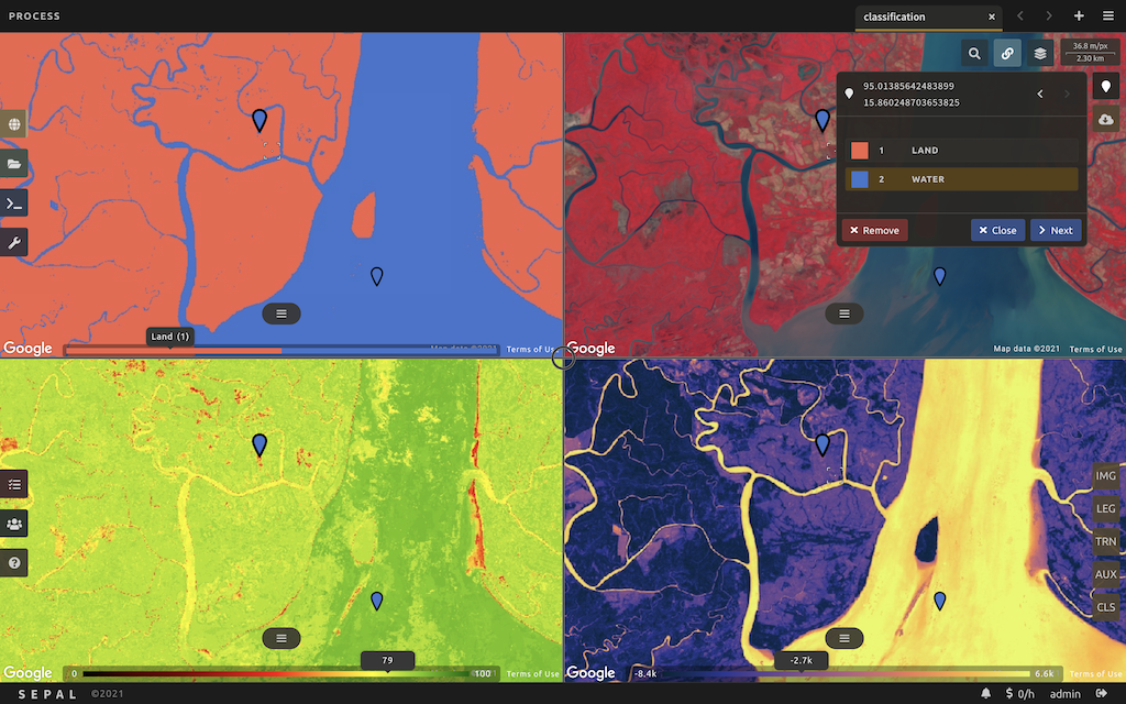
Screenshots
Resources
Support Forum
Github
Materials & Resources
- SEPAL sub-site on FAO
- SEPAL online course draws global audience to advance capacities for forest and land monitoring
- FAO, INPE, UNDP and the Brazilian Governments join forces to improve data accuracy assessments for better forest monitoring
- SEPAL: A powerful, open-source platform for forest and land monitoring