
Collect Earth
Enabling sustainable land monitoring through powerful image interpretation


Latest Version: 1.23.12 (Last Updated: 2026-06-26)
Collect Earth is a free, open-source desktop tool for monitoring land with satellite images. It enables users to view, interpret, and record information using imagery from Google Earth Pro and Google Earth Engine. The solution is fully integrated with Open Foris Collect, which is used to design surveys with flexible structures and tailored objectives.
A key strength of Collect Earth is its ability to analyze land over time. By comparing historical and recent satellite images, users can track land-use changes such as deforestation, reforestation, and land degradation, and evaluate how landscapes evolve. This makes it valuable for forest monitoring, activity data collection, map accuracy assessments, project evaluation as well as for wider applications in agriculture, urban studies, and socio-economic surveys.
Check out the ChatGPT - Collect Earth Assistant
Key Features
Key features introduction paragraph. Offline Data Collection: Collects data without internet connectivity, enabling fieldwork in remote and challenging environments. Offline Data Collection: Collects data without internet connectivity, enabling fieldwork in remote and challenging environments. Offline Data Collection: Collects data without internet connectivity, enabling fieldwork in remote and challenging environments.

Current high-resolution satellite imagery
Access and analyze historical and current high-resolution satellite imagery through Google Earth Pro and Google Earth Engine.
Time-series analysis
Tracking land-use change such as deforestation, reforestation, and land degradation.
Flexible survey design and management
Flexible survey design and management using Open Foris Collect with customizable questionnaires.
User-friendly desktop application
User-friendly desktop application that works both online and offline, accessible without specialized hardware.
Advanced data validation and QA/QC
Advanced data validation and QA/QC with customizable rules, constraints, and built-in checks to ensure consistent, transparent, and high-quality results.
Integrated with IPCC activity data reporting
Integrated with IPCC activity data reporting to support national greenhouse gas inventories and climate reporting.
Support for reporting to international conventions
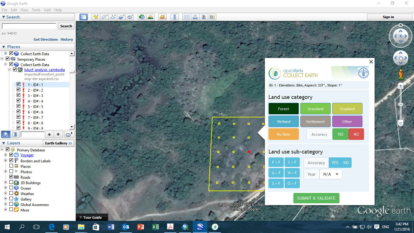
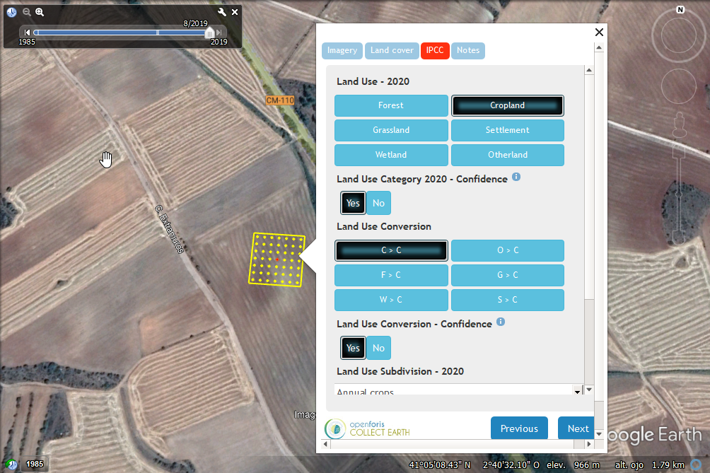
Robust data collection methodology that is consistent with recognized standards, such as the land use representation defined by the Intergovernmental Panel on Climate Change (IPCC).
Multi-language support
Multi-language support to facilitate use in different countries and contexts.
Downloadable, analysis-ready data
Downloadable, analysis-ready data in formats such as CSV, KML and XML for easy integration with other systems.
Wide range of applications
Wide range of applications including forest inventories, REDD+, GHG reporting, accuracy assessments, agriculture, urban studies, and socio-economic surveys.
Open-source and transparent
Open-source and transparent, all code is publicly available on GitHub, ensuring reproducibility and adaptability.
Designed For
Arena Mobile caters to a broad spectrum of users engaged in field data collection activities related to environmental monitoring, natural resource management, and socio-economic research. Arena Mobile particularly benefits decision-makers through improved data reliability, streamlined workflow from collection to analysis through the integration with Arena for reporting.
Key target audiences and use scenarios include:
National Forestry Agencies
Forestry agencies use Arena Mobile to conduct National Forest Inventories, enabling consistent, large-scale forest data collection and long-term monitoring.
Project Staff & Facilitators
Government or NGO staff who manage data collection campaigns, oversee users, and prepare data for reporting.
Data Collectors & Stakeholders
Trained technicians, students, or local community members who classify plots using the intuitive visual interface — enabling large-scale participation.
Policy & Decision Makers
Institutions and governments that use Collect Earth outputs for national planning, climate reporting, and international conventions.
Educators & Trainers
Universities, research institutes, and capacity-building initiatives that use Collect Earth as a teaching and training tool.
Workflow & Architecture
Workflow
- Develop a Data Use Plan & Engagement Strategy: Define who will use the data, how it will be communicated, and which decisions it will support.
- Define Indicators & Area of Interest: Align survey content with monitoring goals (e.g., land use, tree cover, restoration progress).
- Design the Survey in Open Foris Collect: Create flexible questionnaires with validation rules and logic. Collect contains templates to generate IPCC-compliant surveys or to create a fully customizable Collect Earth survey.
- Design the Sampling Scheme: Set up statistically robust sampling grids (systematic, stratified, random). You can use the Collect Earth Grid Generator tool.
- Training & Capacity Building: Provide training to interpreters and stakeholders on survey design, classification rules, and the use of Collect Earth to ensure consistency and minimize misclassification.
- Export Survey: Export the finalized survey and sampling framework into a Collect Earth project (.cep) file that can be shared with the interpreters.
- Import Survey & Grid: Open surveys in Collect Earth with plots displayed in Google Earth Pro.
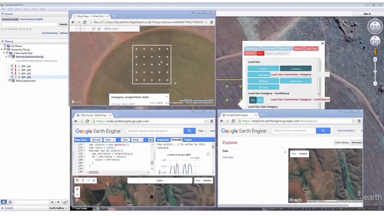
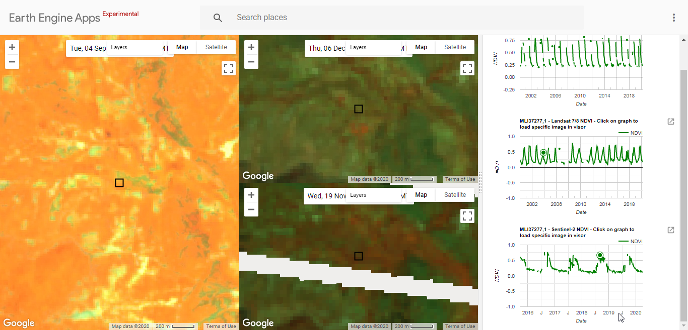
- Interpret Multi-Source Imagery: Use high- and very-high-resolution imagery (Google Earth Pro) to classify land use/cover and track changes over time through integration with Landsat and Sentinel archives (via Google Earth Engine) from 2000 onwards.
- Mapathons & Participation: Organize collective data collection events (learn more on mapathons) to engage experts, students, and communities — scaling up efforts while improving accuracy and ownership.
- Data Storage and Management: Information is securely saved in a local SQLite database on each interpreter's computer. For multi-user projects, a super user manages data consolidation by collating all collected plots into a single master database.
- Quality Assurance: Built-in validation rules and logic check for consistency and errors. The earlier validation rules and checks are built into a survey, the higher the quality of the data collected.
- Quality Control: Saiku, a business intelligence tool integrated within Collect Earth, allows you to explore, query, and visualise the data you collect. It helps identify inconsistencies while the survey is still in progress, so you can iteratively refine validation rules. At the same time, it enables you to provide feedback to image interpreters, helping them improve the accuracy of their image-based observations.
- Groundtruthing (Optional): Field verification to strengthen confidence in results or combine Collect Earth data with other verified datasets for validation.
- Export Analysis-Ready Data: CSV, XML, KML, and other formats for use in other tools such as Excel, QGIS, GEE, R, or Python. You can also use the integrated Saiku BI tool to generate reports and statistics from the data collected and export as graphs or analysis.
- Generate Statistics & Indicators: The exported data can then be used to produce robust statistics, for example on deforestation, reforestation, land degradation, and land-use transitions.
- Further usage to support International Reporting: Tailored feature within Collect Earth to generate IPCC Greenhouse Gas Inventory ready reporting data.
- Tailored Communication: Results can be shared as maps, infographics, dashboards, or one-page briefs, ensuring findings are accessible to decision-makers, practitioners, and local communities.
Screenshots
Resources
Downloads
